| Other Products |
 |
|
|
 |
GPS Vehicle Tracking System |
| |
 |
| |
GPS Tracking device acquire GPS signals from GPS satellites and calculates its position on the earth. This position data is sent to the gpsofindia.com server using GPRS connection made by a integrated GSM-GPRS modem using idea cellular or airtel SIM card. This process is repeated every minute. In case GPRS connectivity is not available temporarily , the device will record the position in its memory and send it later when connectivity is established. Also in case the GPRS connectivity is not available for longer duration, it can send the position data by SMS to the server. In this way the position data of the vehicle is continuously recorded by our server gpsofindia.com.
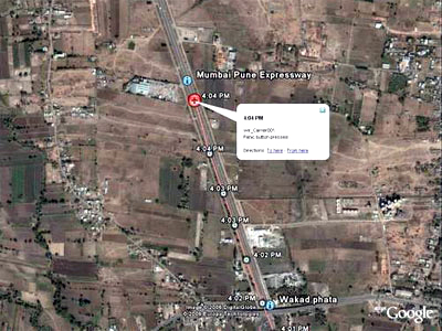
Every customer is provided with web based login account to access the data on the gpsofindia.com server. You can track one or more vehicles using single account. On login our dashboard page displays important information about the vehicle like its status, max speed, motion hours, Distance covered, stationery hours. It provide you a Live Tracking link for Google Earth or Google Maps. In case you have installed free software from google called Google Earth on your computer, then just click on the Google Earth Live Tracking Link in your account and you can see the complete track of your vehicle for today along with fantastic Google earth satellite imagery.
Google Earth Satellite Imagery for most cities (like top 20 cities) in India is available with very good resolution and you can see roads and buildings clearly and identify them. New feature offered by google called Google community inside Google Earth allow you to see placemarks and names of various buildings, roads and key places in the city.
Along with Google earth and Google maps, we have provided various reports for vehicle owners like Start-stop report which gives information about when the vehicle started, where it stopped, for how long and approx distance covered on a particular day. Day Begin-End report give more details about the vehicle from early morning to late night. Detailed activity report gives detailed information about movements of the vehicle in a day. Other reports like Speed report, Fleet Summary report are also available. We also give customers access to detailed transaction history of the vehicle which can be exported to pdf or excel files for their further analysis.
Customers can also use Google Earth to create list of placemarks in the city like office, store, suppliers and customer locations where the vehicle normally travels. If these locations are marked in Google earth and placemarks provided to our system, then in reports you can see, when did your vehicle reached these locations and how much time they were parked at these locations.
Overall we have developed a system that is useful for individuals, corporate and travel transport companies as well as Fleet owners. Individuals can use it to track usage of their car by other family members, driver and friends. They can also ensure security of the vehicles and recover and track them in case its stolen. . Corporate can use our system to monitor and manage company owned vehicles, avoid misuse, increase their availability at right places at right time. Travel transport companies and Truck fleet owners can manage their fleet of vehicles to give optimum output, avoid misuse, take quick actions in case of emergency and more. Our System can be used in any country where GPS cellular services are available.
Our System has been designed to be cost effective and service oriented.
Do I need to buy SIM card from Airtel ?
No, Airtel SIM card will come packaged with the unit and you are not required to buy it. The Airtel SIM card is locked with the Tracking unit and cannot be used for any other purpose except for tracking with the original Tracking unit.
Can I buy my own SIM card from Airtel for use with Tracking unit ?
No, you can only use SIM card offered by us. No other SIM card will work with our Tracking unit.
Will I be charged for roaming and get different bills every month ?
No, Our monthly/quarterly charges are fixed and same everywhere in India. You are required to pay for one quarter in advance and there are not extra cost above your monthly fixed charges.
Is this service available anywhere in India ?
Our Tracking unit will work only with Airtel networks in India, If airtel network is not there then it will not work even if some other network is available. Yes, you can buy this product anywhere in India.
Will GPS tracking work anywhere ?
GPS signals can be received only out doors. i.e. when you are on road, in car etc. GPS signals cannot be received inside the home/buildings though they may be received near windows etc. Hence even though the Tracking unit is working all the time, it can send GPS signals only when you are outdoors. If you go inside a building or house where GPS signals are not available, it will continue to report the last location detected. Also at some places Airtel GPRS signals may not be available, in this condition the device will record the GPS data and report back to the server when Airtel GPRS signals are available again.
How does Tracking unit work ?
Tracking unit will capture GPS signals from GPS satellites and send them to our website gpsofindia.com by using GPRS connection from Airtel network. This will be done continuously till the Tracking unit is ON. This data is recorded by gpsofindia.com and displayed in dashboard, reports and maps for your tracking. There are several situation in which it may not send data to the server like if GPS signals are not available, if Airtel GPRS connection is not available, if unit is power off, if unit is faulty.
Please remember that GPS and GPRS are two different technologies. GPS help calculate location on the earth, whereas GPRS help send this information to the server. Live Tracking is possible only by combination of GPS and GPRS. GPS is available free of cost anywhere on the earth, whereas GPRS is available from Cellular Network operators like Airtel at monthly usage charges. GPS signals cannot be received inside home or building, whereas GPRS signals normally work inside the home/building also. our Tracking unit is one of the worlds most compact and handy unit with inbuilt rechargeable battery.
Do I need to make any payment for licensing GPS, GPRS services ?
No, all licensing is managed by gpsofindia.com and you are only required to use our service. You are not required to pay any third party or take any permissions from government departments.
Is GPRS available everywhere in India ?
As per Airtel its GPRS signals are available at all places where they have network. Airtel operate GSM cellular network is all circles in India and GPRS is advanced features of GSM cellular network and as per Airtel it is available at all places. gpsofindia.com has not tested availability of GPRS availability at all location and does not take any responsibility for the same. Customers are requested to call Airtel and verify if their GPRS networks are active in their region.
Do I need to do any settings in my Tracking unit and install it ?
No, Tracking unit come pre-configured with all settings, SIM card and integrated battery. You need to just power it on like a mobile phone and it starts working. Our Tracking unit can be used inside the car, or can be carried in pocket. It can be charged using chargers provided for mains (in home) and car. We have made it very simple to use the Tracking unit. Anyone who has used mobilephone before will find it very easy and even more easy to use compared to mobilephone. If you intend to use the tracking unit for security of your car, then you need to install it at some hidden place where GPS+GPRS signals can be received but no one can easily detect that your car has inbuilt GPS Tracking system. Our unit is very compact and can be installed by most car mechanics. Our unit only needs power supply from car to work. You should test the performance of the unit before planning any installation.
Can I receive SMS or talk using Tracking unit ?
No, SMS and voice calls have been disabled and cannot be used. Also tracking unit does not have any LCD display or Keypad. It has just one SOS key for emergency alerts.
When do I get my username & password ?
After your order, you receive username and password along with the parcel for the Tracking unit. Your account is already active and if you power on your unit and keep it near window/outdoor. You should be immediately able to see its status as active in your account.
Do you offer Maps for all cities ?
gpsofindia.com service is based on free Google maps and Google Earth. Google maps and Google Earth are available for all cities in India. To view your Tracking unit in Google earth, your have to install latest version of Google Earth software from http://earth.google.com and click on the link available in your web account. Save this link and open it in Google Earth. Later you can see your vehicle moving live in Google earth if you are connected to the internet. You can view your vehicle from any PC where Google Earth is installed for best performance on maps. In case you are at place where google earth is not installed, then you can see your vehicle in web base Google maps provided by us free of cost.
Can I mark my home, office, customer locations on the maps ?
Google Earth provide several tools to mark your placemarks and our system will work with the same. Our system just displays its data on Google earth while supporting all its features. Hence, you can use several useful features of google earth to enhance your experience. For this please visit http://earth.google.com or see Google Earth help.
What are the applications we can use GPS integrated.com ?
GPS Tracking system is internationally used for several applications. We have provided some popular examples.
- Car Tracking: If you use Tracking unit in your car, it will act as a security system which will allow you to locate your car in case of theft. Else it will allow you to track daily/monthly route of your car, to ensure that its not misused. You can also keep check on your driver and family members who use your car. It is very good way to keep track of places your children visit. Some people rent their car and hence can keep track of its location and usage.
- Fleet Management: Corporate can keep track of their fleet of vehicle used by employees and goods transport. It will allow you to avoid misuse of vehicles. It will also allow you to better schedule and manage your vehicles and save fuel cost. You can save upto 10% fuel and time of your vehicles if you deploy Fleet Management system like ours. 10% savings means you can do work of 110 vehicles with 100 vehicles only. |
| |
| GPS Vehicle Tracker |
 |
Introduction :
GPS Vehicle Tracker has designed with SoC (System On Chip) solution to bring more reliability and stability to the over whole performance Indeed, GPS Vehicle Tacker has been ranking as premium car alarm system by insurance companies across the world.
Firmware Feature:
- SOC solutions
- SMS mode/GPRS mode/SMS+GPRS mode
- Upload/download settings, locations, and OS via GPRS.
- Open platform for two way communication between control center and MDT
- Special protocol for GPRS with hand shaking. Minimize communication cost and data package lost.
- MCU dead lock protection
|
| |
| Specification : |
| |
| 1. |
|
GPS Specifications : |
| |
SiRF STAR III chipset version |
Nemerix chipset version |
| |
A) |
General |
| |
1) |
Frequency |
L1, 1575.42 MHz. |
L1, 1575.42 MHz |
| |
2) |
C/A code |
1.023 MHz chip rate |
1.023 MHz chip rate |
| |
3) |
Channels |
20 |
16 |
| |
B) |
Accuracy (Open Sky) |
| |
1) |
Position |
10 meters, 2D RMS. |
7 meters CEP (90%) horizontal, SA off. |
| |
2) |
Time |
1 microsec synchronized to GPS time. |
1 microsec synchronized to GPS time. |
| |
3) |
Velocity |
|
0.1 meters/second |
| |
C) |
Datum |
| |
1) |
Default |
WGS-84. |
WGS-84. |
| |
2) |
Other |
Support different datum by request. |
Support different datum by request. |
| |
D) |
Acquisition Rate (Open sky, stationary requirements) |
| |
1) |
Reacquisition |
0.1 sec., average. |
0.1 sec., average. |
| |
2) |
Hot start |
1 sec., average. |
10 sec, average |
| |
3) |
Warm start |
38 sec., average. |
38 sec, average |
| |
4) |
Cold start |
42 sec., average. |
45 sec, average |
| |
5) |
Snap start |
|
2 sec, average |
| |
E) |
Dynamic Conditions |
| |
1) |
Altitude |
18,000 meters (<60,000 feet) Max |
18,000 meters (60,000 feet) max |
| |
2) |
Velocity |
736 m/s (<1,000 knots) max |
515 m/s (1000 knots) max |
| |
3) |
Acceleration |
4 G, max |
4g, max |
| |
4) |
Jerk |
20 meters/second, max |
20 meters/second, max |
| |
F) |
RF interface |
| |
1) |
RF interface |
Minimum signal tracked: -159dBm |
|
| 2. |
|
GSM Modem Specifications : |
| |
1) |
Power Supply |
Power supply Single supply voltage 3.4V?4.5V
Power saving Typical power consumption in SLEEP mode to 3mA |
| |
2) |
Frequency bands |
Tri-band: EGSM 900, DCS 1800, PCS 1900 or
Tri-band: EGSM 850, DCS 1800, PCS 1900
Compliant to GSM Phase 2/2+
GSM class Small MS |
| |
3) |
Class |
Transmit power Class 4 (2W) at EGSM900
Class 1 (1W) at DCS1800 and PCS 1900
GPRS connectivity
GPRS multi-slot class 10
GPRS mobile station class B |
| |
4) |
Temp. range |
Operating temp. : -25?C to +70?C
Storage temp. : -40?C to +80?C |
| 3. |
|
Electrical Characteristics : |
| |
1) |
Input Voltage |
+9~37 Volt DC regulated / 2A-MAX (GSM Transmit) |
| |
2) |
Power Consumption |
12 Volt?100~320 mA (GPS On Line, GSM/GPRS On Line)
12 Volt?60 mA (GPS on line, GSM standby)
12 Volt?<20 mA (GPS in Power Down Mode, GSM Standby |
| |
3) |
Backup Power |
Nickel Metal Hydride Battery?700 mA |
| |
4) |
Memory Backup |
Flash Memory?Data retention?200 Years.
64 Kbyte (64000 * 8 Bits data) |
| 4. |
|
Case Environmental Characteristics : |
| |
1) |
Op. Temp. |
-25?C to +70?C (board temperature) |
| |
2) |
Output |
4 digital outputs (200mA max) |
| |
3) |
Digital Inputs |
5 |
| |
4) |
Analog Inputs |
1 |
| |
5) |
RJ Ports |
a) 1 RJ11 port for serial RS232 (low speed 9600 Baud) and Direct GPS output RS232 (4800 or 9600 Baud?depending on GPS module)
b) 1 RJ11 port for voice I/O
c) 1 RJ45 MULTI port for HS (115200) Direct modem access (TTL- CMOS). |
|
| |
| Application: |
- Security & fleet management
- Car Navigation
- Marine Navigation
- Vehicle Tracing & Location Base Services
|
| |
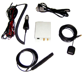
| Packaging List: |
- GPS Vehicle Tracker Unit
- GSM Antenna
- GPS Antenna
- RS232 Cable
- I/O Cable
- CD including User`s Manual, Software program and driver etc.
|
| |
| |
|